LookBermuda/LookTV lookbermuda.com
Indulging your mermaid (or merman) fantasies has never been easier, thanks to the many swim-with-dolphins centers that have popped up in nearly every beach tourist destination. Rarely, however, will you find a dolphin center that treats the friendly sea mammals with the level of devoted care shown at Dolphin Quest in Bermuda. Dolphin Quest is located at the well-respected Bermuda Maritime Museum, where the dolphins live in a safe and secure environment, receive daily health care and are consistently stimulated by games and people. Both children and adults can enjoy the numerous activities, including feeding the dolphins, swimming with them or riding a scooter alongside them while they swim. For the ultimate dolphin experience, try the Trainer for a Day Program, which allows you to assist in health examinations, observe training programs and interact with the dolphins for more than five hours. Though the ultimate fantasy would be to swim with them in the wild, only at Dolphin Quest will you get close enough for a kiss.

A selection on “Sea Level Rise In Bermuda” from the documentary film “Riddle of the Crest” produced and created by Look Bermuda. JP Rouja and Ben Watson.
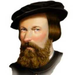
Appearing in Film; Dr Philippe Max Rouja and Professor Steve Blasco


Stuart Hayward introduces the 2008 BIOS Explorer series “On the Rock”. Drs. Andreas Andersson and Samantha de Putron discuss the concepts of ocean acidification, including the importance of carbonate ions and dissolution to coral growth. Meanwhile the BioNauts pump exhaust fumes into seawater to see what happens to its acidity (pH).
2008: On the Rock (Part 2)
With the help of coral researcher Kate Degnan, the BioNauts undertake an experiment to investigate the effects of ocean acidification on the growth rate of live coral. They also conduct a fish bite count while snorkelling on a local reef in order see just how much damage parrot fish do to the coral while feeding. Drs. Andersson and de Putron explain how corals reproduce, are ‘recruited’ onto a reef as juveniles and how this formative stage in the life cycle is crucial for the continued health of Bermuda’s reef ecosystem.
2008: On the Rock (Part 3)
BIOS Education Officer JP Skinner explains how Bermuda’s unique cave system has formed over millions of years and in doing so, chronicled changes in sea level as the caves have slowly flooded. Bermudian cave diver Bruce Williams talks to the BioNauts about the wonders (and dangers) of diving the Walsingham caves and the need to protect them for future generations. The BioNauts survey the local coastline for potential new caves systems and take water samples to monitor the levels of pollution
Bermuda Institute of Ocean Sciences bios.edu
A LookBermuda / LookTV production – http://blog.lookbermuda.com/
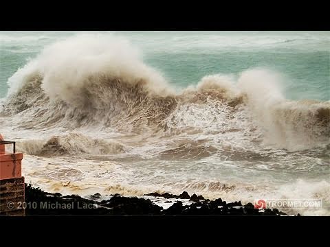
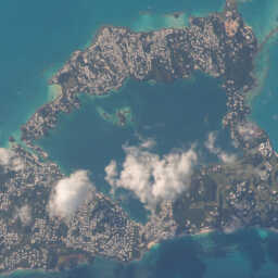
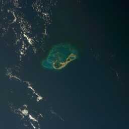
From September 17th – 20th, storm chaser Michael Laca intercepted Hurricane Igor on the island of Bermuda.On September 6th a large and complex area of disturbed weather associated with a tropical wave, moved off the west coast of Africa attended by two distinct areas of low pressure.The dominant low passed to the south of the Cape Verde islands while steadily increasing in organization, becoming a tropical depression on the morning of September 8th and reaching tropical storm strength later that day.For the next couple of days, Igor moved westward reaching hurricane strength late on September 11th. Rapid intensification ensued on September 12th and by late that afternoon, Hurricane Igor reached category four strength with maximum sustained winds of 135 mph (115 kts). An ERC (eyewall replacement cycle) began on September 13th which resulted in a slight weakening, followed by a new period of intensification, culminating in Hurricane Igor’s peak intensity, with the storm producing maximum sustained winds of 155 mph (135 kts) and a minimum central pressure of 925 mb (27.32 mb) late on September 14th. During this time, Hurricane Igor was very near category five intensity After reaching its peak, Hurricane Igor turned toward the west-northwest and began a slow weakening process over the next few days with several additional ERCs observed. By September 16th, the hurricane had weakened to category three intensity while its windfield continued to expand. The weakening trend continued and by September 17th Igor was downgraded to a category two while turning more towards the northwest.
On September 18th, extremely large Hurricane Igor continued to weaken while turning more towards the north. Although weakening, the storm’s massive windfield was producing hurricane conditions outward as much as 105 miles from the storm’s center, with tropical storm force winds extending out near 350 miles. Tropical storm conditions spread across Bermuda by the early morning hours of September 19th and continued to worsen as the day progressed with hurricane conditions reaching the island shortly after nightfall. As Hurricane Igor approached Bermuda, the storm began moving more towards the north-northeast, making its closest point of approach near 11:00pm AST (0300 UTC) while passing 40 miles west of the island. At this time, Igor was a category one hurricane with sustained winds of 75 mph (65 kts) and a minimum central pressure of 955 mb (28.20 in).
With the exceptionally large windfield that Hurricane Igor produced, impacts on Bermuda began well before the core of the storm approached the island. On September 17th, more than two days prior to Igor’s closest approach, large and damaging waves had already reached south facing beaches along the island with several cliff side roadways experiencing overwash from breaking wave crests. Wave heights continued to increase on September 18th with exposed sections of the island’s South Road becoming impassable as huge waves crashed onshore.
By the early morning of September 19th, with Hurricane Igor still over 250 miles away, tropical storm conditions had spread across the island with gusts frequently exceeding 50 mph (45 kts) at my location in Hamilton Parish, on the northwest side of Castle Harbour. Conditions continued to deteriorate throughout the day with the onset of hurricane conditions occuring just after nightfall on the 19th. Peak conditions occurred from 10:00 pm to midnight AST, as Igor passed just to the west of the island. I estimate maximum sustained winds of 75 mph (65 kts) with gusts near 90 mph (78 kts) impacted my location. The minimum pressure I recorded at the Grotto Bay Beach Resort was 965.7 mb (28.52 in) at 10:55 pm AST during a period of rapid pressure fluctuations, followed by a temporary recovery to 983.3 mb (29.03 in) at 12:25 am on the 20th, and then a second minimum of 966.7 mb (28.55 in) at 3:25 am. Sustained tropical storm conditions impacted my location for approximately 36 contiguous hours.
The highest officially reported winds on Bermuda during Igor’s passage were 74 mph (64 kts) with a peak gust of 93 mph (81 kts) from the official weather observing site at L.F. Wade International Airport (approximately two miles east-northeast of my location). A peak gust of 89 mph (77 kts) was also observed from an elevated location on the island. The lowest official pressure on the island was 965 mb (28.50 in), though storm chaser Mike Theiss observed a pressure of 964 mb (28.47 in) at Elbow Beach.
Tropmet.com is a web destination dedicated to hurricanes, tropical cyclones, tropical meteorology, severe weather and storm chasing. The site is owned and maintained by veteran storm chaser, Michael Laca.
Read more about Hurricane Igor here


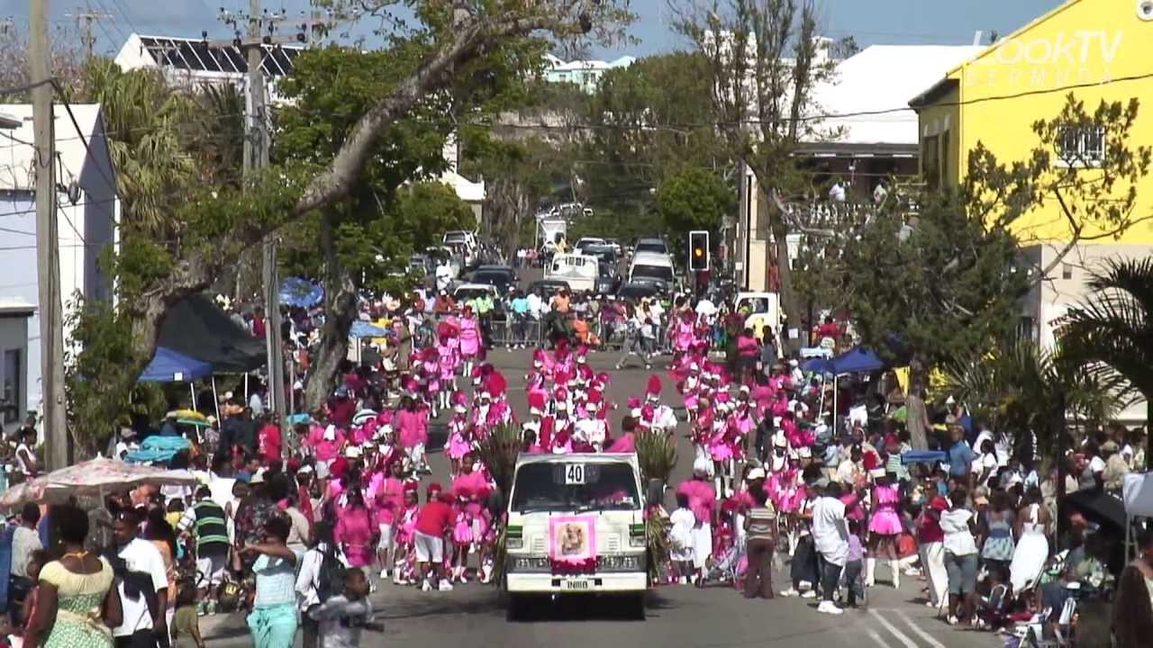
The Warwick Gombey Troupe have been performing for locals and visitors for decades. Gombeys (pronounced GOM-bays) have been dancing around Bermuda for almost two centuries. A mix of West African, Caribbean and Native North American dances have combined to influence their rhythmic moves.
Gombey
The Gombey is an iconic symbol of Bermuda, this folklife tradition reflecting the island’s blend of African, Native American, Caribbean and British cultures, incorporating them over time into a unique performance art full of colorful and intricate masquerade, dance and drumming.
Dancers are usually male, and perform in groups of 10-30 though in modern times female groups have emerged. The traditions have been passed down orally from one generation to the next within families and the Captains of each troupe determine the direction of the troupe and style that is taught. Thus within troupes there can be found subtle but distinct differences in beats, dances, costumes, headdresses, by which they can each be recognized.
Read full wiki: en.wikipedia.org/wiki/Gombey

3 videos. 25 mins
3. Various scenes of Bermudian life showing market scenes, fishing, washing, villages, loading bananas at dockyard, street scenes and a ship leaving the island at night.
Filmmaker: Allen Fraser
For more information on the archives and these films, please visit: gov.ns.ca


At the Bermuda National Trust, those in the know take you back through the history of the island. Stops along the way include The Tucker House, The Verdmont House and The Old Rectory dating back to the 1600s.